The Tackabury brothers were a family of map, business directory and atlas publishers who established themselves in London, Canada West around 1860. Like the Tremaine map making family, who were discussed in the November 2024 issue of Families,[1] the Tackabury brothers grew up in Upper New York State, but set their sights on breaking into the potentially lucrative Canada map publishing business. Throughout 1861, 1862 and 1863 a very public spat arose between the Tackabury brothers and the more established Tremaine family as they raced against each other to produce large commercial wall maps of Canada West. This article will explain who the Tackabury brothers were, discuss their accomplishments, and try to make sense of their feud with the Tremaine family.
The Irish Protestant Tackabury Family Arrives in Upper New York State
There are varying reports about the ethnic origins of the Tackabury family (Scottish or Dutch),[2] but the common point of emigration for the protagonists in this story is early nineteenth century County Wicklow in Ireland, just south of Dublin on the Irish Sea. Nathaniel Tackabury (1768-1851) arrived in the USA on 28 June 1807[3] and settled in Pratt’s Hollow, Eaton, Madison County, New York along with a closely knit group of Irish Protestant families also from Co. Wicklow.[4] With him was his wife Sarah Julia (Neusum) Tackabury and their Irish born children. The families of two of those children are relevant to this narrative, the eldest James Tackabury and his younger brother John Wesley Tackabury, both of whom settled initially in Madison County, NY with their parents. James remained there and John Wesley moved to Upper Canada.
James Tackabury (1795-1884)
After some initial financial struggles James became a successful farmer in Madison County and with his wife Anna Belton (1797-1879) raised seven sons and four daughters (an eighth son died in childhood).[5] Three of these sons became involved at one time or another in the family map publishing enterprises – Robert Middleton Tackabury (1826-1906),[6] George Neusum Tackabury (1828-1894)[7] and Rev. Samuel T. Tackabury (1832-1888).[8] During the 1840s these three sons and a fourth brother attended Cazenovia Seminary, a Methodist supported school, which would have given them a solid academic foundation.[9]
The extended family of James Tackabury were variously reported in Pratt’s Hollow, Eaton, Oneida, Lenox, Canastota and Cazenovia, all within a 15 mile radius of each other, 30 miles east south east of Syracuse, NY. This was 80 miles south of Rodman, NY where the Tremaine family had settled a few years earlier.
John Wesley Tackabury (1804-1877)
John W. Tackabury was nine years younger than his brother James and in 1828 married Elizabeth Belton (1807-1875), who was a younger sister of James’ wife Anna. The marriage was in Pratt’s Hollow where their first child was also born. In approximately 1829[10] John and Elizabeth moved to London Township, County of Middlesex, Upper Canada. They were following in the footsteps of Elizabeth’s Belton and Webster family members.[11] They settled eventually in an area on the Thames River which came to be known as The Grove, located just west of the dam which in 1952 created current day Fanshawe Lake and its conservation area.[12] A portion of this Tackabury land was donated for the Grove School which closed in 1960 and another plot for the Wesleyan Methodist Church located on Clarke Road until 1980. The Tackabury family ultimately owned over 600 acres in the area, including the land now occupied by the London Airport and Fanshaw Conservation Area.[13] They and their twelve children and descendants were an influential family in the Clarke Road / Grove area of London Township. I have yet to find evidence that members of this family were involved directly in the map making business, but it is quite likely that they were in some capacity.
Tackabury Brothers Map, Directory and Atlas Publishing
The three New York Tackabury brothers who were involved in publishing maps off and on between about 1858 and 1901 were often in partnership with a variety of other individuals and companies. The most prominent and common of these collaborators was Henry Francis Walling (1825-1889).[14] The first documented map published by the Tackabury Brothers was a wall map of Connecticut and its Cities published by Richard Clark & Tackabury Brothers in 1859. Shortly after the Connecticut map was published Richard M. and George N. Tackabury began promoting a Canadian Advertising Directory and a supporting Canada West wall map (more on this later). The following chart documents a selection of maps, directories and atlases which the Tackabury Brothers were involved with. Maps with a Canada focus are unshaded. Rev. Samuel T. Tackabury was less involved than his brothers Richard M. and George N. and is only credited as a publisher on the 1873 first edition of the Atlas of Michigan.
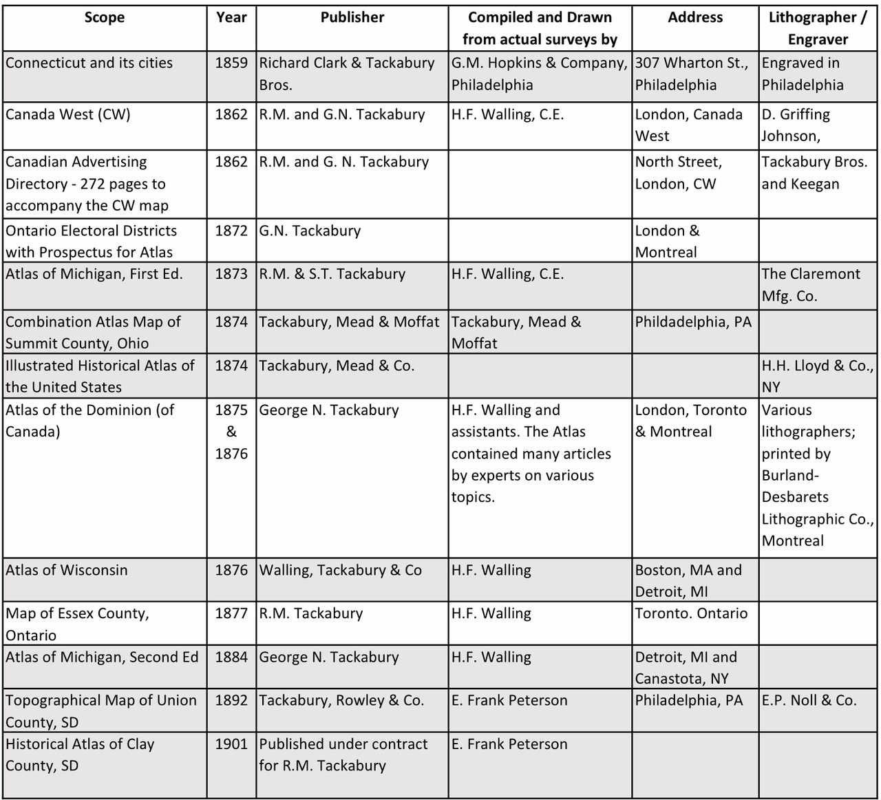
Exhibit 1 – Tackabury Brothers Maps,
Business Directories and Atlases [15]
George N. Tackabury was also involved with Rev. E.J. Clemens, another Cazenovia Seminary alumnus, in publishing some of the Silent Teacher and Kindergarten Geography dissected puzzles in the 1880s. One example in the Norman B. Leventhal Collection of the Boston Public Library has a Tackabury map of the USA on one side and a Clemens Map of Pennsylvania on the reverse side.[16] The pieces were cut on the Pennsylvania map county borders. Such map puzzles were one of the earliest forms of dissected puzzles which, after the invention of the jigsaw, became known as jigsaw puzzles in the twentieth century.[17]
The New York Tackabury Brothers Get Established in Canada
In about 1860, at the ages of 30 and 32, the brothers Richard M. and George N. Tackabury established a base of operations in the City of London, County of Middlesex, Canada West, close to where their uncle, aunt and double first cousins had settled in London Township (see previous John Wesley Tackabury section). It may only be a coincidence, but 1860 was also the beginning of the Civil War between the States.
In 1862 the Tackabury Canadian Advertising Directory, containing 272 pages of detailed information about the commerce of the Canadas, was published.[18] It had a pronounced London and Middlesex County orientation, as measured by the percentage of advertisers and pages devoted to that area, and is therefore particularly useful to researchers of that county. The 1862 Canada West wall map to be discussed in the next section was intended to accompany this directory. Per its sub-title, the Directory also contained a Brief History of Canada, From Its Discovery to the Present Time, Every Post Office in Western Canada, alphabetically arranged, giving the Township and County, with the name of the Postmaster, and various other Statistical Information.
The 1862 Canada West Wall Maps
Both the Tackabury Brothers and the Tremaine Family concluded in about 1860 that there was a commercial market for a large Canada West wall map. In November 1859 Thomas Devine, Head of Surveys, Upper Canada Branch, Crown Lands Department, had published a very creditable map titled the Government Map of Canada from Red River to the Gulf of St. Lawrence.[19] The intent of both Tackabury and Tremaine was to focus on Canada West with more detail and content on a larger format for commercial sale.
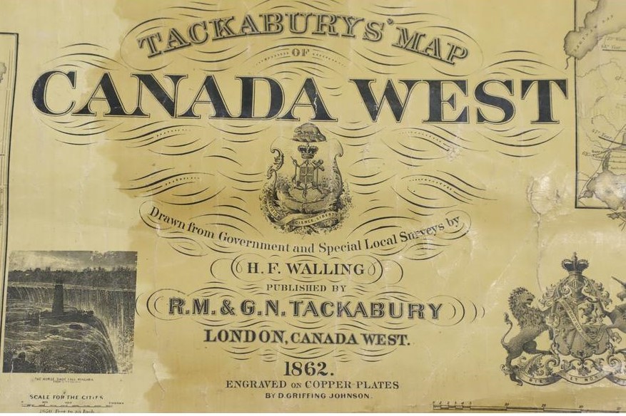
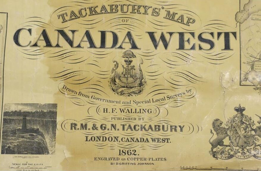
Exhibit 2 – 1862 Tackabury Cartouche [20]
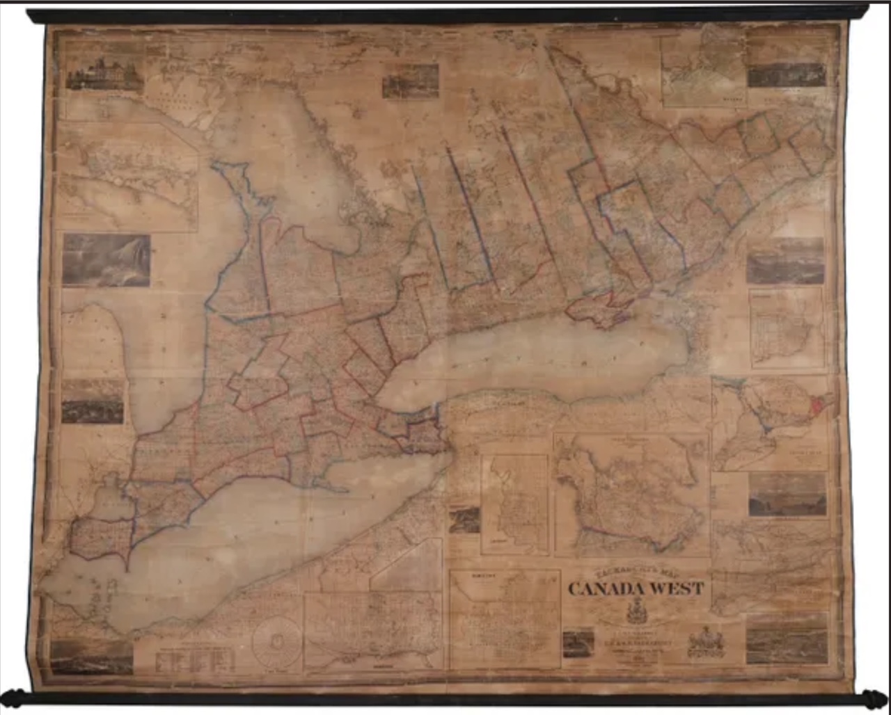
Exhibit 3 – 1862 Tackabury Map [21]
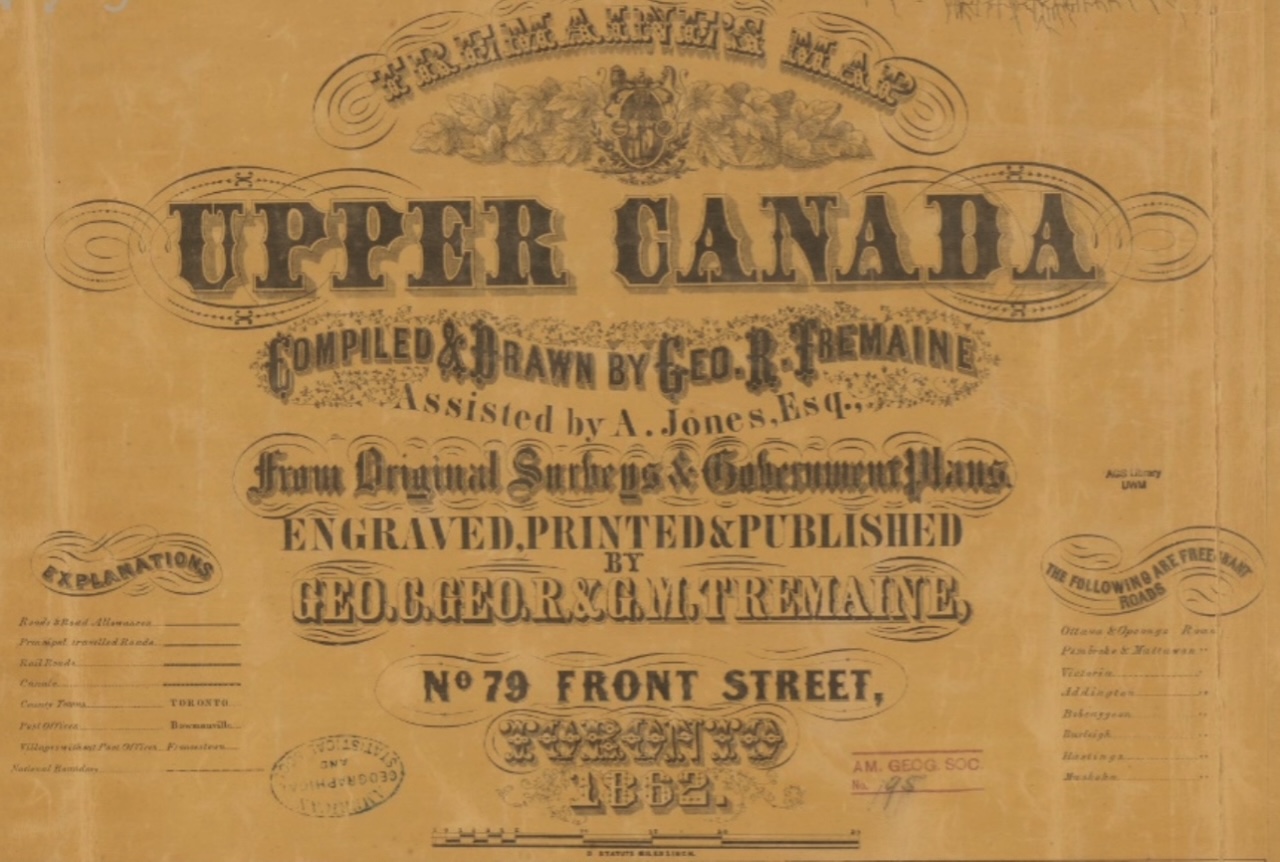
Exhibit 4 – 1862 Tremaine Cartouche [22]
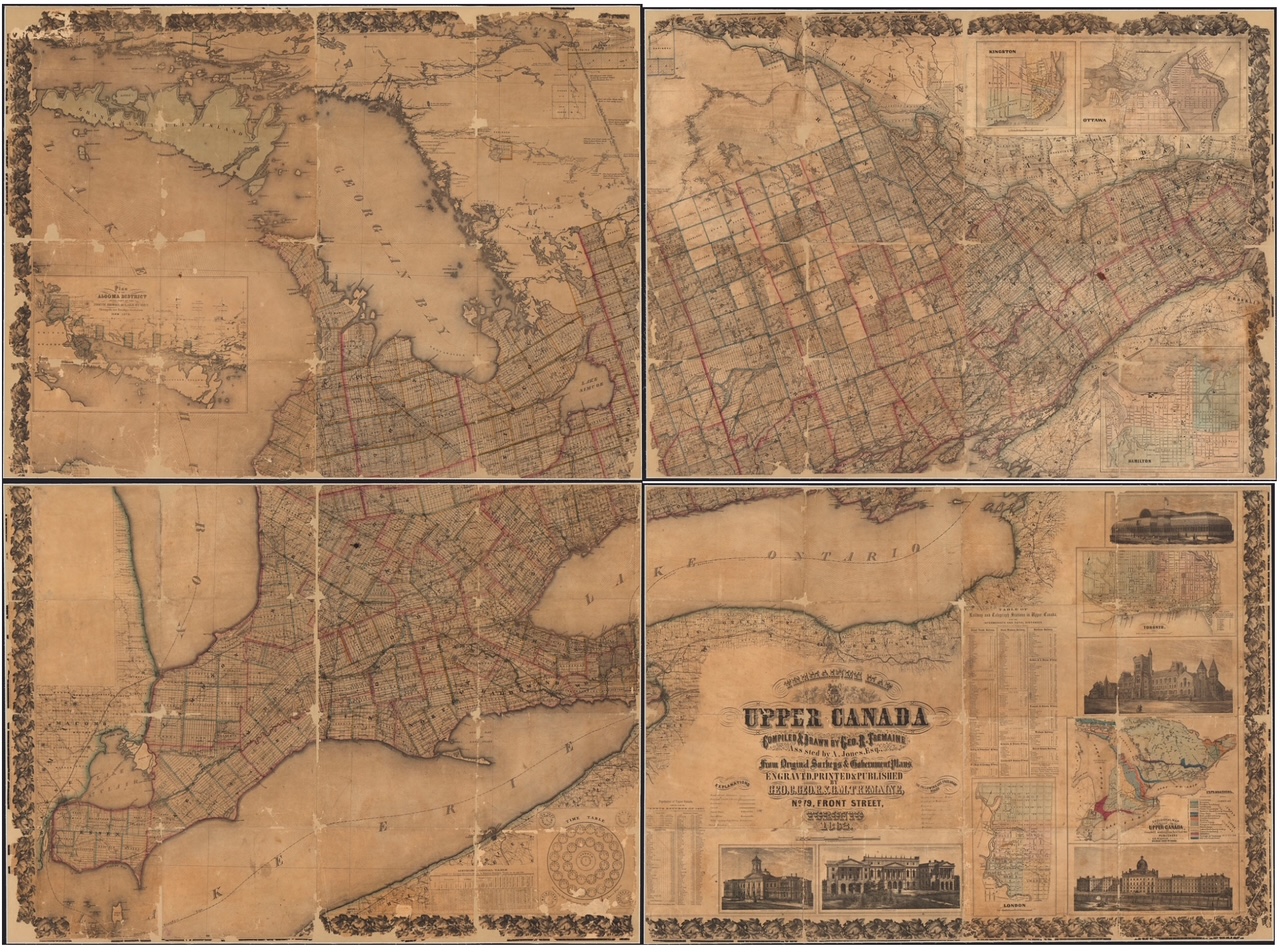
Exhibit 5 – 1862 Tremaine Map [23]
Both maps were published in 1862, 22 years after the Act of Union combined Upper and Lower Canada into the Province of Canada with its Canada East and Canada West regions. It is interesting to note that Tremaine still named their map Upper Canada. These were large wall maps with the dimensions of the Tackabury map at 155 x 191 cm. and the Tremaine map only slightly larger and more rectangular at 156 x 219 cm. The scale of the Tackabury map was 6 inches to the mile and the Tremaine map was 5 inches to the mile.
The Tackabury map contained several informative smaller maps and tables in the margins. There was a Population Chart by city; a Time Table for cities (important before the days of regulated time zones); a Distances Chart; inset maps of Toronto, Hamilton, London, Kingston and Ottawa; a Climatological Map by Lorin Blodget; a Geological Map derived from the work of Sir William E. Logan; a map of the British Possessions of North America; and Vignettes of important buildings, natural features and towns.
The Tremaine map also had Vignettes of important buildings and natural features, an inset map of the Algoma District, a list of telegraph offices, and many of the same type of tables, charts and city maps as Tackabury.[24]
Sadly, I’ve not been able to locate a high-resolution online scan of the 1862 Tackabury map, though there are reasonably good scans of the 1862 Tremaine map (see endnote [22] for the url of the Library and Archives Canada four quadrant scans). A number of museums in Ontario list paper copies in their catalogues, but these maps are not as numerous as the various county wall maps published during the same time period. Another source for comparing these maps is the book Ontario’s History in Maps available at many libraries.[25] This book also includes more detailed crops of the newly settled areas around Georgian Bay to help contrast the two maps.
The Preface of the 1875 & 1876 Tackabury’s Atlas of the Dominion of Canada[26] provides some insights into the Tackabury Brothers business model. It indicates that the entire financial responsibility and ownership of the 1862 Canada West wall map, which was published under the names of R.M. and G.N. Tackabury, resided with H.F. Walling, the engineer and surveyor who compiled and drew the maps. It goes on to state that Walling lost heavily on the venture. The rights to market the map were entrusted to the Tackabury Brothers as the publisher. This was a crucial function as it involved a cadre of door-to-door salesmen to canvas the entire province to solicit subscriptions. It is likely that the publication of a competing map in 1862 by the Tremaine family was a major factor in those financial losses and may explain some of the animosity which arose between the two publishers.
The Feud and Counter Claims
Perhaps due to the financial risks associated with the production and sale of these competing maps, an acrimonious and very public feud broke out between these two map publishing families. Each purchased advertisements in newspapers and directories throughout the province criticizing the other’s character and map while also singing the praises of their own product. The key elements of the feud included accusations of non-Canadian production, debates over the quality of the map making processes used, assertions of plagiarism, and the comprehensiveness of the detail on the maps. The following information will help make some sense of the competing claims.
The Home Enterprise Claims:
Both parties accused the other of using non-Canadian production and in the case of the Tackabury Brothers, Tremaine accused them of being interlopers to Canada. No evidence has been found that any of the three map-making Tackabury brothers were active in Canada before about 1860, though their close relatives had settled in London 30 years earlier. The Tackabury brothers’ children were all born in the USA (except one in London, CW in 1862) and they and their families were all enumerated in the USA on the Federal and State censuses and directories of the period. George C. Tremaine, the head of the Tremaine Map Establishment, moved to Canada West from New York in the early 1840s and resided there until his death in Prince Edward County in 1882.[27] His two nephews, George Richard Tremaine and Gaius Monroe Tremaine, who were key members of the map business, were likely in Canada West for only about eight years from 1856 to 1864 before returning to the USA.
In George C. Tremaine’s 21 Dec 1860 Prospectus for his “Large and Elaborate Map of Canada West”[28] he stated that “we have also, at a great expense, imported Materials, Presses, &c. of the best kind, for engraving, printing, and Manufacturing Maps, and having Engravers and Lithographers of acknowledged skill, the artistic portion of the work will be equal to any produced by the best houses either in New York or London.” He also states in a newspaper advertisement that the paper to be used will come from the Don Mills, by Messrs. Taylor & Brothers.[29] Tremaine had built a map establishment in Toronto during the process of compiling county maps and controlled most of the production process, including the map compilation and drawing.
Tackabury claimed that 100% of their work was done in London, CW[30] but Tremaine asserted that they had evidence that the drawing, engraving, printing and most of the mounting was done in the USA[31] where the map compiler (H.F. Walling) and engraver (D.G. Johnson) were based. Tackabury Brothers & Keegan advertised a print operation on North Street, London, CW, but it is unclear if it would have been able to handle these large-scale wall maps.
Copper Plate vs. Stone Engraving:
Tackabury claimed their copper plate engraving technique was superior.[32] It was generally considered that copper plate did produce a better-quality map and was also easier to correct than stone engraving or lithography.
Stone lithography was a cheaper technique for producing a map as it did not require an engraver to inscribe a reverse image on a copper plate. Instead, an image was often drawn on a transfer paper which was applied to the stone. Tremaine, in an advertisement, acknowledged that he was engraving on stone.
In September 1862 both maps were hung next to each other at the Arts and Manufactures Department of the Provincial Exhibition in Toronto. The Tremaine map was awarded a $6 prize and a Diploma and the Tackabury map was awarded a $4 prize.[33] Both companies made reference to these awards to promote their maps and both companies produced testimonials which claimed the superiority of their map.
Accusations of Plagiarism:
Most maps are derivative to some extent, particularly in Canada West where map makers would each have to rely on Township and Crown Land surveys. Tremaine claimed in newspaper articles that Tackabury was using the various county maps published by Tremaine and others as the base for their Canada West map. The Tackabury map compiler H.F. Walling was, however, also a skilled cartographer, familiar with parts of Canada West. Between 1860 and 1863 he drew four county maps in eastern Ontario in collaboration with D.P. Putnam. The Tremaine’s had completed or were in the process of preparing 14 county maps, mostly in the western and central part of Canada West. They therefore had access to extensive survey data sources.
Comprehensiveness of Maps:
Tackabury published an advertisement describing numerous omissions in the Tremaine map.[34] Tremaine replied with a claim that Tackabury omitted northern townships until after they were published by Tremaine, and detailed numerous other flaws.[35]
Marketing of the Maps:
Both publishers relied heavily on newspaper advertisements to promote their maps, supported by a team of local agents and field solicitors of subscriptions. Both maps sold for $6.00. In mid-nineteenth century Canada West most towns had at least two newspapers, often supporting opposing political parties. Similarly, these newspapers often supported one or the other of the map publishers. There was also a geographic bias given the Tackabury connections in London, CW and Hamilton while the Tremaine family had more support in Toronto and Kingston.
In early 1861 Tackabury was very critical of the Tremaine map stating that “the public is cautioned to beware of imposition, as parties are endeavoring to obtain Subscribers for a Map which purports to be similar, but is only intended to be a lithographic map, made on stone, which can in no way compare with a Copperplate Engraving.”[36] Tremaine claimed in several articles that the Tackabury agents were bad mouthing their competition and suggesting that Tremaine would fold before a map was produced. In a published 26 Aug 1862 letter Geo. C. Tremaine described “the pretentions set up … the deceptive management, the promises and the deficiencies relating to the rival maps”.[37] In a widely published letter John Ferris Ward, brother-in-law of Geo. C. Tremaine, was very critical of the Tackabury Brothers calling them strangers, Yankees, plagiarizers and liars among other accusations.[38]
Tackabury responded with a testimonial defending their map signed by 30 men, eight of whom were Professional Land Surveyors (PLS).[39] Like George N. Tackabury, some of the signatories were members of the Masonic Lodge.
Based on the analysis above, the Tackabury map contained more information and was slightly more finely engraved, though it is difficult to assess the initial quality of 162 year old maps, whether restored or in deteriorating condition. H.F. Walling was a more experienced cartographer than George R. Tremaine and A. Jones, who compiled the Tremaine map, as was the engraver D.G. Johnson. On balance the Tremaine claims that the Tackabury Brothers were interlopers in Canada and imported their maps likely held some truth and the claims of plagiarism may also have had some merit, though this was not at all unusual in the map business.
The Tremaine nephews left Canada in 1864 but George C. Tremaine continued to publish significant new Canadian maps in 1865 and 1866 with his final one in 1872.[40] Shortly after George C. Tremaine retired in 1872 George N. Tackabury resumed operations in Canada and produced a very substantial Atlas of the Dominion of Canada in 1875 and 1876 (see below). In 1877 Richard M. Tackabury published a map of the County of Essex, compiled again by H.F. Walling.[41] During the 1880s George N. Tackabury was listed in the Lovell’s Directories with a Montreal business address while also being listed in New York business directories and censuses as residing in Canastota, NY. After the 1870s most Tackabury publishing activity was focused on Michigan, Wisconsin and South Dakota.
The 1875 and 1876 Atlases of the Dominion of Canada
Tackabury’s Atlas of the Dominion of Canada, published by George N. Tackabury, was the most comprehensive and significant contribution which the Tackabury Brothers left to Canada. This 258 page atlas, with 130 coloured maps compiled and drawn by H.F. Walling, was an invaluable addition to the geographic record of post Confederation Canada.[42] There were two editions in 1875 and 1876 and they sold for $12.00. The 1876 edition added the Tackabury name to the front of the map title as noted in Exhibit 6 below.
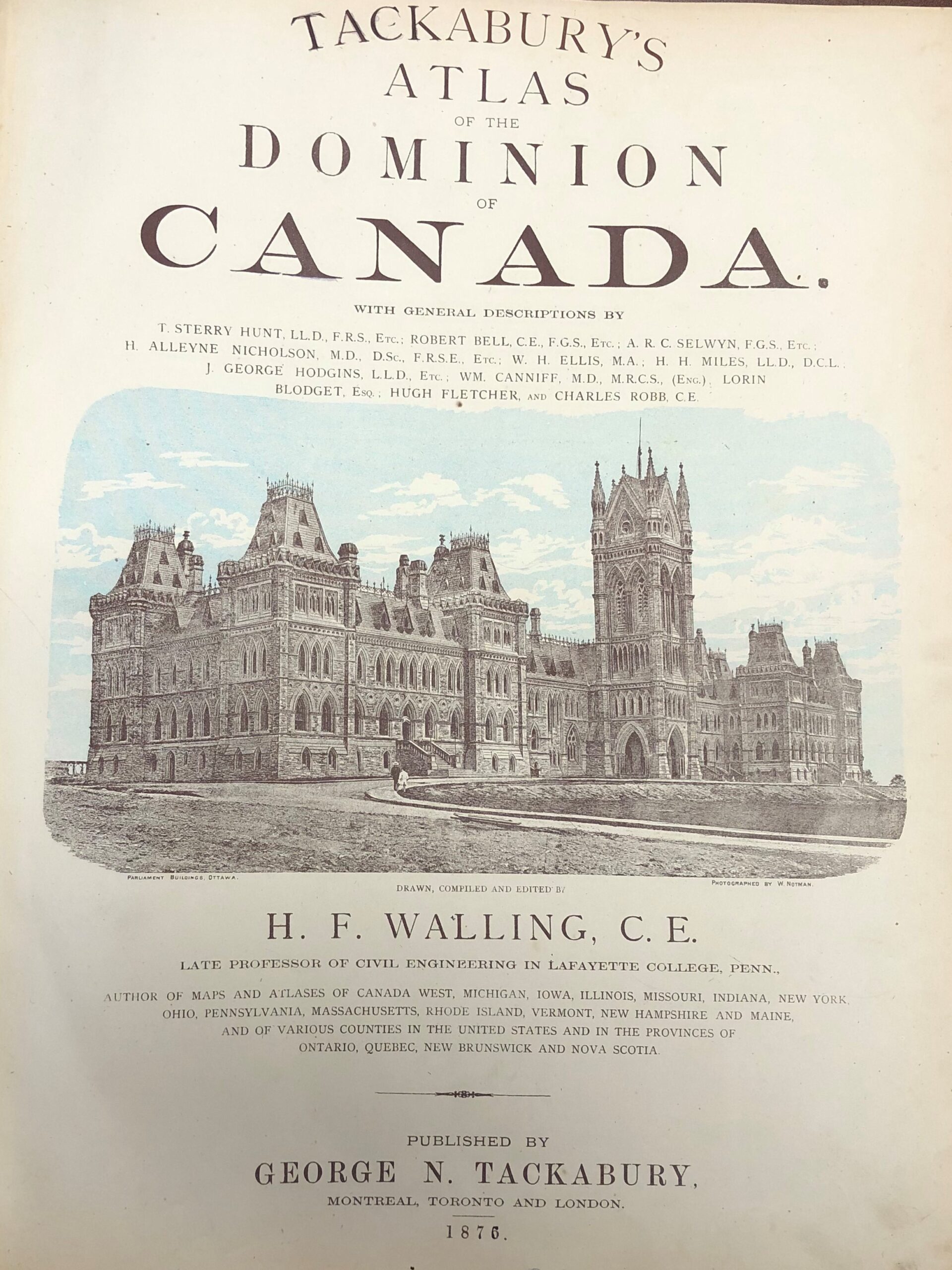
Exhibit 6 – Title page of 1876 Tackabury’s Atlas
of the Dominion of Canada [43]
During the same time period that the Tackabury Atlas was published a wide variety of more detailed individual County Atlases were also emerging.[44]
Legacy of the 1862 Maps
Tackabury Brothers have acknowledged that their 1862 Canada West wall map was not a financial success, and the small number of copies which survive suggest that the print runs were not large. A similar assumption can be applied to the Tremaine map. Careful examination shows that both maps have a wealth of geographic content, but neither have the level of granular detail contained on the many County maps of the period. The County maps therefore provide the potential for much more significant genealogical content. The rapidly changing face of Canada West, supercharged by Canadian Confederation in 1867, also made the maps quickly obsolete. Their main value in hindsight may be the way in which they can be used, in combination with other maps published in earlier and later periods, to show the evolution of the settlement of Canada West during this seminal period, in particular the road and rail networks and distribution of post office, telegraph and mail order outlets. Clearly the more established Tremaine family greatly resented the competition which they faced from the H.F. Walling and Tackabury Brothers map establishment and the public dispute between the two publishers became visceral and vitriolic. It is unlikely that either profited from the competition over the 1862 maps, though both went on to success with subsequent projects.
———————————————————–
[1] Graham Segger, Tremaine’s Map Establishment, Families (Toronto, Ontario Genealogical Society, Nov 2024), v63-4, p39-44
[2] It would be nice if one of the readers of this article had access to Tackabury DNA records which could help resolve the matter of the origins of the Co. Wicklow Tackabury family
[3] Date of arrival in the USA per Kenneth Scott, compiler, British Aliens in the United States During the War of 1812 (1979: Baltimore, Genealogical Publishing Company Inc.) p222. The information in Mr. Scott’s book was based upon the US Marshalls Returns of Enemy Aliens and Prisoners of War, 1812-15.
[4] Lynch, Tooke, Marshall, Philpot, Tackabury, Kern families per a marker in the Fairview Cemetery. Also settling in Madison Co., NY from Co. Wicklow, Ireland was the Belton and Dickenson family. There were variations in the eventual spelling of the surname among the offspring of Nathaniel with some adopting Tackaberry.
[5] The Leading Citizens of Madison County New York (Boston, Biographical Review Publishing Company, 1894) p33
[6] Robert Middleton Tackabury (RMT) was born in Madison Co., NY on 01 Oct 1826. RMT married Celina Kendal (1836-1905) and together they had five children between 1863 and 1878. They lived at various times in Cazenovia and Syracuse, NY; Detroit, MI, and Vermillion, SD. RMT died in California but was buried in Vermillion where he had been involved in publishing several of E. Frank Peterson’s maps and atlases.
[7] George Neusum Tackabury (GNT) was born in Madison Co., NY on 20 Jul 1828. GNT and his wife Lucretia Shapely (1828-1901) had eight children, three born in Madison County, NY between 1856 and 1860, one born in County of Middlesex, Canada West in 1862, and four more in Madison Co., NY between 1864 and 1872. George became a very successful citizen of his community and maintained a substantial home – Evergreens, Peterboro St., Canastota for the last 30 years of his life. He was a prominent member of the Methodist Church and the Free & Accepted Masons. George Wesley Tackabury, son of GNT, was born in London, Canada West on 26 Jul 1862 but was living in Canastota when he married in 1896. His profession was listed as publisher on his marriage registration, suggesting that he may have been involved in the family map business.
[8] Rev. Samuel T. Tackabury (STT) was born in Madison Co., NY on 18 Mar 1832. He married twice, first to Mary Catharine Watkins and second to Alice J. Force and had one daughter, Eloise. STT was a preacher, first in the Methodist church, and then in the last six years of his life as an early Jehovah’s Witnesses adherent. He wrote extensively for their publication Watch Tower – https://truthhistory.blogspot.com/2016/02/samuel-tachabury.html.
[9] First Fifty Years of Cazenovia Seminary: 1825-1875 (Cazenovia, NY, 1877) (familysearch.org). This college operated under various names throughout the eighteenth century including Genesee Seminary, Oneida and Genesee Conference Seminary, Oneida Conference Seminary and Central New York Conference Seminary. In 1867-8 Rev. Samuel T. Tackabury was on the Board of Visitors and in 1870 Geo. N. Tackabury was on the Board of Official Visitors
[10] Derived from birth dates of their first and second children and various London Township historical records
[11] For a comprehensive history of the family and descendants of John Wesley Tackabury and Elizabeth Belton see Winnifred Whitehall McCall, Tackabury Genealogy, 1804-1960 (London, ON, 1980) 65 pages (available on microfilm in the London Public Library)
[12] They first lived on the N ½ of London Township Lot 1, First Concession and then purchased Lot 4, Third Concession being 200 acres from Edward Hale. Instrument 2141, registered 4 June 1853. The author recalls racing in Y Flyer sailboat regattas on Fanshawe Lake in the late 1960s and visiting the Conservation Area during his later university days.
[13] A brief Tackabury family history can be found in London Township (Arva Ontario, London Township History Book Committee, 2001) p487-8
[14] The map making legacy of Henry Francis Walling (1825-1889) was quite extraordinary. He was a civil engineer, cartographer and surveyor who created hundreds of maps of towns, counties, states, provinces and countries in the USA and Canada. In Canada he collaborated with both D.P. Putnam and the Tackabury Brothers. https://www.geographicus.com/P/ctgy&Category_Code=walling
[15] This list was assembled through review of a wide variety of map archive catalogues, authoritative lists of maps published in nineteenth century North America and commercial map dealer websites.
[16] Tackabury Brothers were listed on the box containing one of the early Silent Teacher dissected maps as the publisher. The Leventhal collection map is displayed at the following link https://collections.leventhalmap.org/search/commonwealth:3f463976z
[17] For more information about the evolution of dissected map puzzles and the Silent Teacher series see the YouTube video of a June 2021 presentation by Dr. Anne Williams to the Chicago Map Society – https://www.youtube.com/watch?v=OYd9thXE-fQ
[18] Tackabury Brothers’ Canadian Advertising Directory (London, R.M. & G.N. Tackabury, 1862) – https://www.canadiana.ca/view/oocihm.57871/1
[19] The American Geographical Society Library Digital Map Collection, University of Wisconsin Milwaukee has a high-resolution scan of the Devine map available on its website – https://collections.lib.uwm.edu/digital/collection/agdm/id/34292/
[20] Image courtesy of the Oshawa Museum. A restored copy of the Tackabury map is installed on the wall of the Henry House Library. Community Engagement Coordinator for the museum Lisa Terech has written two informative blogs about the map https://oshawamuseum.wordpress.com/2013/09/20/the-tackabury-map/ and https://oshawamuseum.wordpress.com/2015/11/13/my-favourite-artifact-the-tackabury-map/
[21] Image of map listed for sale by Vetus Carta Rare Maps – https://vetuscarta.com/products/xn-tackaburys-map-of-canada-west-yd2r . Used with permission.
[22] Crop from a partial (3 quadrant) copy of the Tremaine map in the American Geographical Society Library Digital Map Collection, University of Wisconsin, Milwaukee – https://collections.lib.uwm.edu/digital/collection/agdm/id/34048 . Used with permission.
[23] This map was created by combining the four quadrants of the public domain Tremaine’s Map of Upper Canada compiled and drawn by Geo. R. Tremaine assisted by A. Jones, Esq., from original Surveys and Government Plans. Source: Library and Archives Canada / Item ID # 4128044 (NMC11259). – https://recherche-collection-search.bac-lac.gc.ca/eng/Home/Record?app=fonandcol&IdNumber=4128044&ecopy=e011165065_a1-v8 . The LAC copy is very similar to the partial three quadrant University of Wisconsin Milwaukee copy. A comprehensive list of the contents of the map is included in the LAC details record. The Ontario Archives has a copy of an 1862 Tremaine map of Upper Canada which contains the same principal map as the copies in other archives, but the border vignettes are different. The AO version has a Table of Telegraph Offices, eight public buildings and seven countryside sketch vignettes on the border but no inset maps. The other copies have a Geological Map, Time Table, Meteorological Table, Population Chart, Telegraph Offices, five city maps and five public buildings. The AO copy also lacks the A. Jones compilation credit suggesting he may have had a hand in the additional tables and maps. A low-resolution copy of the AO map can be viewed at https://www.archives.gov.on.ca/en/explore/gallery/big/tremaines-map.aspx
[24] Joan Winearls, Mapping Upper Canada 1780-1867: An Annotated Bibliography of Manuscript and Printed Maps (Toronto, Ontario: University of Toronto Press, 1991) Item 277(1) contains a record of another 1862 map of Upper Canada published by John H. Holden, with lithographers Geo. R. and G.M. Tremaine. This map appears to have been published with a focus on Cramahe Township in Northumberland County and its principal town of Colborne. The Tremaine map is documented as Item 277(2) in this book and the Tackabury map as 280. Winearls documents five states of the Tackabury map published, with most changes affecting the border charts, maps and vignettes rather than the main map.
[25] Ontario’s History in Maps, R. Louis Gentilcore and C. Grant Head (Toronto, University of Toronto Press, 1984). The Tremaine map is on p52 and the Tackabury map is on p54.
[26] H.F. Walling, Atlas of the Dominion of Canada (Montreal, Toronto and London, George N. Tackabury, 1875) Preface p1 – https://www.canadiana.ca/view/oocihm.25497/10.
[27] Segger, Tremaine’s Map Establishment. Per census records, obituaries and various other records documented in the article
[28] https://www.canadiana.ca/view/oocihm.57852/1
[29] Geo. C. Tremaine, The New and Improved Map of Upper Canada (advertisement), Kingston Whig Standard (Kingston, CW, 08 Sept 1862): p1. Mr. Tremaine’s letter contained in the advertisement was dated 26 Aug 1862.
[30] Tackabury Brothers’ Canadian Advertising Directory, p16
[31] John Ferris Ward, Notice (advertisement), Hamilton Times (Hamilton, CW, 27 Aug 1862: p3.
[32] New Copper Plate Map of Canada West, Messrs. Tackabury Brothers & Co. of London, Canada West (advertisement), The Hamilton Spectator, 6 Mar 1862: p8. The letter published in the article was dated 6 Feb 1861. There were many other such advertisements published across Canada West during 1862.
[33] The Journal of the Board of Arts and Manufactures for Upper Canada, December 1862, p363 – https://www.canadiana.ca/view/oocihm.8_06643_24/12
[34] Tackabury Brothers, Notice to Map Purchasers (advertisement), The Hamilton Spectator (Hamilton, CW, 23 Feb 1863) p3. This advertisement ran at least 14 times between Dec 16, 1862 and July 25, 1863.
[35] The Canadian Almanac and Repository for Useful Knowledge, (Toronto, W.C. Chewett & Co., 1863) p101
[36] Hamilton Spectator, 6 Mar 1862, p3
[37] Kingston Whig Standard, 08 Sept 1862, p1
[38] Hamilton Times, 27 Aug 1862, p3
[39] Public Testimonial to Messrs. Tackabury Brothers (advertisement), The York Herald (Richmond Hill, 12 Sept 1862) p3
[40] Segger, Tremaine’s Map Establishment, Exhibit 1
[41] Map of Essex County – https://recherche-collection-search.bac-lac.gc.ca/eng/home/record?idnumber=3987507&app=FonAndCol
[42] Walling, Atlas of the Dominion of Canada – https://www.canadiana.ca/view/oocihm.25497/10 . This is the 1875 edition.
[43] Image courtesy of Archives and Special Collections, Brock University (G 1116S1 W356 1876)
[44] See The Canadian County Atlas Digital Project sponsored by McGill University – https://digital.library.mcgill.ca/countyatlas/primarysource.htm and https://digital.library.mcgill.ca/countyatlas/searchmapframes.php ; Most of these atlases were published by H.R. Page & Co. or H. Belden & Co.